Florey ACT 2615
2,139 addresses · 99 streets
Fenner Electorate › Unincorporated ACT LGA › Florey · 9 km from Canberra
📦 Thinking of moving here? Read the Florey moving guide

Living Here
Florey is a suburb of Australian Capital Territory, home to about 4,781 people, with a median age of 39. The typical household earns around $2,082 a week, with median rent near $415 a week. Most homes are houses. About 64% of households own their home and 34% rent. Most workers drive to work. Common community backgrounds include English, Australian, Irish. On the ABS socio-economic scale it sits in decile 8 of 10 nationally — a relatively advantaged area.
Over time — Census 2001 → 2021
Dashed line: district figures for the Florey statistical area (SA2), the smallest area the ABS published before 2011. Solid line: Florey itself.
Getting Around & Local Services
16 parks
17 doctors & medical clinics
4 optometrists
31 playgrounds
- Kesteven Street Central Community Playground
- Boswell Crescent Neighbourhood Playground
- Hewlett Circuit Neighbourhood Playground
- Tattersall Crescent Neighbourhod Playground
- Meyrick Place Neighbourhood Playground
- Totterdell Street (North) Neighbourhood Playground
- Western Foreshore District Playground
- Belconnen Learn to Ride Centre
- Broadsmith Street Neighbourhood Playground
- Burkitt Street Neighbourhood Playground
1 dog park
2 hardware stores
Getting around. Bus interchange: Cohen Street, 1.6 km south-east · Airport: Canberra Airport, 15.6 km south-east.
Socio-economic Standing
Deciles from 1 (lowest) to 10 (highest), against all Australian suburbs. The overall figure weighs advantage and disadvantage together; economic resources counts income and housing, and education & jobs counts qualifications and occupation. They often differ. Source: ABS SEIFA 2021.
Tree cover
🌳 Tree canopy: 11.9% share of land under canopy · satellite map, 2020
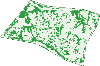
Green: 10 m cells where trees dominate, satellite 2021. Blue: water. The line is the suburb boundary.
| Canopy share, 1 m canopy height map, 2020 | 11.9% |
|---|---|
| Land with trees, 10 m satellite map, 2021 | 27.9% |
Demographics
Unemployment 4% · Labour-force participation 63.4%
Population by age in Florey
| 0-4 | 257 |
|---|---|
| 5-14 | 568 |
| 15-19 | 233 |
| 20-24 | 309 |
| 25-34 | 695 |
| 35-44 | 681 |
| 45-54 | 557 |
| 55-64 | 674 |
| 65-74 | 514 |
| 75-84 | 231 |
| 85+ | 69 |
Dwelling types in Florey
| House | 1,403 |
|---|---|
| Townhouse | 415 |
| Apartment | 8 |
| Other | 0 |
Households by weekly income in Florey
| <$650 | 238 |
|---|---|
| $650-1,499 | 379 |
| $1,500-2,999 | 570 |
| $3,000+ | 532 |
Top ancestries in Florey
| English | 1,457 |
|---|---|
| Australian | 1,446 |
| Other | 807 |
| Irish | 540 |
| Scottish | 435 |
| Chinese | 293 |
Housing tenure in Florey
| Owned | 595 |
|---|---|
| Mortgage | 574 |
| Rented | 624 |
| Other | 23 |
Cars per household in Florey
| 0 | 125 |
|---|---|
| 1 | 679 |
| 2 | 694 |
| 3 | 217 |
| 4+ | 96 |
Commute to work in Florey
| Car | 1,620 |
|---|---|
| Train | 3 |
| Bus | 114 |
| Tram/ferry | 0 |
| Walked | 41 |
| Bicycle | 35 |
| Home | 248 |
Top countries of birth in Florey
| India | 156 |
|---|---|
| Vietnam | 156 |
| England | 122 |
| China | 121 |
| Philippines | 83 |
| Nepal | 62 |
Languages used at home in Florey
| Vietnamese | 222 |
|---|---|
| Mandarin | 124 |
| Cantonese | 68 |
| Nepali | 67 |
| Spanish | 66 |
| Urdu | 61 |
Birds & Wildlife Nearby
672,689 bird observations recorded near Florey — most often seen:
- Australian Magpie (43,277)
- Red Wattlebird (42,385)
- Pied Currawong (39,553)
- Sulphur-crested Cockatoo (38,749)
- Crimson Rosella (37,822)
- Magpie-lark (36,451)
- Galah (36,074)
- Australian Raven (26,080)
- Crested Pigeon (25,591)
- Eastern Rosella (25,343)
- Eurasian Blackbird (25,142)
- Common Starling (24,812)
- Silvereye (23,746)
Show all 30 birds recorded near Florey
- Common Myna (23,692)
- House Sparrow (23,414)
- Superb Fairy-wren (17,823)
- Australian King-parrot (17,421)
- Weebill (16,368)
- Spotted Pardalote (16,303)
- Eastern Spinebill (15,273)
- Striated Pardalote (14,795)
- Yellow-rumped Thornbill (13,472)
- Black-faced Cuckoo-shrike (13,396)
- Grey Fantail (12,067)
- Noisy Friarbird (11,755)
- Rainbow Lorikeet (11,191)
- Gang-gang Cockatoo (10,717)
- Willie Wagtail (10,469)
- Yellow-faced Honeyeater (10,430)
- Laughing Kookaburra (9,078)
Sightings reported by observers, not a survey, so the counts show what people record rather than what lives here. Source: Atlas of Living Australia.
Nearby Suburbs
The closest suburbs to Florey:
Embed this suburb
Add this free Florey stat card to your own site — just copy the code:
Preview:
Cite this page
Quoting these figures? Copy the credit line:
Keep an eye on Florey
One email when this data meaningfully changes — new census figures, prices, rankings. No spam, unsubscribe anytime.
Streets
- Audas Place (15)
- Bagster Place (9)
- Barnard Circuit (59)
- Beddome Place (27)
- Belfield Crescent (15)
- Bibby Place (10)
- Boan Close (15)
- Boas Place (15)
- Bolliger Place (6)
- Boswell Crescent (38)
- Bowley Place (15)
- Brunnich Place (11)
- Bryce Place (5)
- Byram Place (6)
- Caddy Place (7)
- Camfield Place (25)
- Carne Place (11)
- Cayley Place (8)
- Challinor Crescent (30)
- Clavert Place (18)
- Clements Street (7)
- Colefax Place (8)
- Cooksey Place (9)
- Cooling Place (42)
- Craig Place (9)
- Cuscaden Crescent (23)
- Dalton Place (16)
- Dannevig Place (9)
- Dendy Place (9)
- Eddy Crescent (47)
- Edman Close (22)
- Elkington Street (23)
- Ennor Crescent (49)
- Enright Crescent (40)
- Fawsitt Place (11)
- Fielder Place (11)
- Flecker Place (34)
- Freney Place (12)
- Gabriel Place (28)
- Gard Place (13)
- Gatliff Place (8)
- Greenup Close (11)
- Hamblin Place (11)
- Hamlet Place (16)
- Hayden Close (18)
- Herman Close (14)
- Hewlett Circuit (31)
- Heymann Place (8)
- Illidge Place (8)
- John Cleland Crescent (173)
- Kesteven Street (38)
- Kidd Place (3)
- Kitson Place (9)
- Krefft Street (28)
- Laidley Place (15)
- Lambie Place (6)
- Le Souef Crescent (25)
- Lidgett Place (17)
- Lightfoot Crescent (57)
- Longley Place (13)
- Lumholtz Place (11)
- Maccallum Circuit (56)
- Mcaulay Place (11)
- Mellor Circuit (46)
- Meyrick Place (16)
- Musson Close (30)
- Nanson Place (15)
- Pawsey Circuit (34)
- Playoust Place (11)
- Priestley Place (12)
- Quaife Place (8)
- Quayle Place (20)
- Ratcliffe Crescent (69)
- Roughley Place (24)
- Rupp Place (5)
- Sayce Place (4)
- Shellshear Place (10)
- Skertchly Place (12)
- Sloane Place (12)
- Spry Place (7)
- St John Crescent (29)
- Sticht Place (12)
- Stroud Place (29)
- Summers Place (10)
- Summerville Crescent (104)
- Tadgell Place (15)
- Tattersall Crescent (29)
- Thorpe Street (7)
- Tiegs Place (8)
- Tovey Place (9)
- Tunney Crescent (24)
- Twelvetrees Crescent (64)
- Wadham Place (12)
- Whitelegge Close (14)
- Whittell Crescent (29)
- Woolnough Street (14)
- Worrell Place (24)
- Wragge Place (6)
- Zwar Place (11)